chargement...


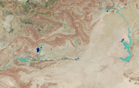
The Sahara Desert experienced an unusual heavy rainfall event this September, bringing significant precipitation to parts of Morocco, Algeria, Tunisia, and Libya.
NASA’s Moderate Resolution Imaging Spectroradiometer captured the resulting runoff and floodwaters in satellite imagery, showing dark blue areas where water had accumulated. While most of the rain fell in sparsely populated areas, several villages in Morocco were hit by destructive flash floods, causing infrastructure damage, reported NASA’s Earth Observatory on Saturday.
Moshe Armon, a senior lecturer at the Hebrew University of Jerusalem, described this event as unique due to the involvement of an extratropical cyclone. «The system formed over the Atlantic Ocean and pulled moisture from equatorial Africa into the northern Sahara, resulting in unusually heavy rainfall», he explained.
Preliminary satellite analysis indicated rainfall accumulations ranging from tens to hundreds of millimeters in the affected areas, roughly matching the region's annual rainfall. These estimates were based on IMERG data, which is particularly valuable for assessing precipitation in the Sahara due to the lack of ground-based rain gauges and radar stations.
Armon and his team analyzed two decades of IMERG data to understand the frequency of heavy precipitation events in the region. They found that, while hundreds of such events have occurred, only a few were associated with an extratropical cyclone.