chargement...


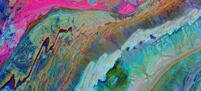
From afar, the new image released for the first time by NASA looks like a stunning tie-dye painting. But in fact, the photograph, published Thursday, is a satellite picture that depicts the unique form of Morocco’s Anti-Atlas Mountains.
To photograph the Anti-Atlas, a mountain range in Morocco also known as the Lesser Atlas or Little Atlas, the United States’ National Aeronautics and Space Administration (NASA) used «infrared bands to depict different rocks and show complex folding», wrote Fox News.
The colorful image was taken on November 5, 2007, by NASA’s Terra satellite, a multi-national scientific research satellite in a Sun-synchronous orbit around the Earth, wrote the federal agency in a communiqué that featured the portrait.
According to the same statement, the photograph gives a bird's-eye view of the Moroccan mountain range. Indeed, it shows how «the limestone, sandstone, claystone and gypsum layers that formed the ocean bed were folded and crumpled to create the Anti-Atlas Mountains», NASA explained.
A never seen before image of the Anti-Atlas Mountains
To the aeronautics and Space agency, the Kingdom’s Lesser Atlas was «formed as a result of the collision of the African and Eurasian tectonic plates about 80 million years ago». «This collision destroyed the Tethys Ocean», an ocean during much of the Mesozoic Era located between the ancient continents of Gondwana and Laurasia, before the opening of the Indian and Atlantic oceans during the Cretaceous Period, it added.
«In thisimage of southwest Morocco, visible, near infraredand short wavelength infrared bands are combined to dramatically highlight the different rock types, and illustrate the complex folding».
The Anti-Atlas Mountains image is one of the many photographs taken by the ASTER instrument on the Terra satellite and acquired by NASA. These photos are part of Terra’s mission, launched 20 years ago.
Commemorating its launch in December 1999, NASA recalls that the satellite was built to «last for six years and 30,000 orbits». However, it miraculously managed to operate for 20 years, providing data about planet Earth and its mountains.


 Fil Info