chargement...


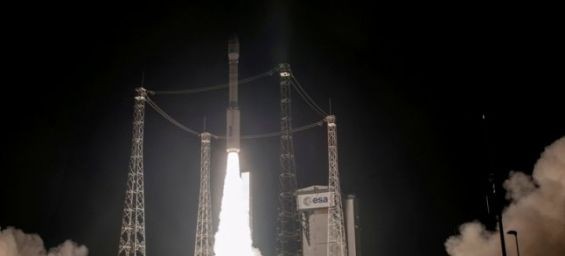
After the launch on Nov. 8, 2017 of the first satellite Mohammed VI-A, the second Satellite Mohammed VI-B was successfully launched on Wednesday by Arianespace via its Vega rocket, from the Kourou launch site, in French Guyana.
The implementation of this program has been given to the Thales Alenia Space and Airbus consortium and it spans five years. Mohammed VI-B satellite is fully managed, just like the Mohammed VI-A satellite, by Moroccan engineers and technicians who have benefited from long specialized training, both in Morocco and abroad.
In agriculture, the use of technology and new techniques, including geospatial information derived from satellite remote sensing, is an effective way to manage agricultural resources as well as to plan and implement strategies for efficiency and durability.
Thanks to satellite imagery and its combination with information on soils, meteorological data, field observations, operators in the field of agriculture to access date related to the sector and find means to increase agricultural production.
This technology also offers cartographic data for a better management of space and irrigation means, an accurate supervision of the crop year, management of forest resources and curbing related risks.
In urbanization, Satellite imagery allows having products with different scales of territorial intervention. It provides up-to-date information on urban tissue and other related themes and their spatial distribution.
In oceanography, this technology is an indispensable source of information for the knowledge and monitoring of marine parameters at spatial scales and at variable temporal frequencies, such as sea surface temperature and indicators derived from water color data, in addition to the indicators of marine pollution, particularly by hydrocarbons.
Satellite images are also exploited for the valorization of fish resources and their spatial and temporal evolution through, the monitoring of indicators describing the environmental conditions.


 Fil Info